Never been there. Couldn't say.
Yep....NOTHING is easy about the Rubicon trail been going since 2003.
What makes it "easier" is technology improvements, skill and 40's
Never been there. Couldn't say.
Just do it on 35's with 1310's. It'll be plenty challenging...haha.LOL!! Been a while since I've seen this thread.
There's still fun to be had on the Rubicon but it's a far cry from being what it once was. I get that people are doing what they need to "keep it open" but I'm not real fond of the way a lot of them start to act like they own the trail. This goes for a lot of the trails that are "adopted" by clubs.
I'll be in South Lake Tahoe tomorrow afternoon, and on the Rubicon Monday morning...
Sent from my iPhone using WAYALIFE mobile app
I'll be in South Lake Tahoe tomorrow afternoon, and on the Rubicon Monday morning...
Sent from my iPhone using WAYALIFE mobile app
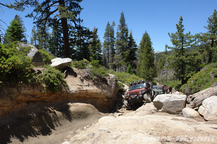
The Gatekeeper
Up until about 2005, the very first 100 yards or so of the Rubicon Trail's Loon Lake entrance was strewn with large boulders and was given the name, The Gatekeeper. As the name implies, if you couldn't get through this first section of trail, it'd be in your best interest to turn around and head back home. Even after the biggest rocks were cleared, the Gatekeeper still offered some challenge up unti about 2010. After that time, work crews came in to crack up more of the big boulders and fill in the rest of the voids with crushed rock.
The Trough
There used to be a length of trail just past Ellis Creek that split off in two with one side requiring you to climb a large granite boulder to the left, and the other having you work your way through a boulder and log strewn trench to the right. I don't know if this lower section of trail had an official name but, we always referred to it as "The Trough". As of 2011, this lower section has been permanently closed off.
Snorkel Eater
Just past Quarter Panel Rock, there used to be a significantly off camber length of trail that wasn't actually scary to traverse as the most that would happen is that you'd tip your passenger side windshield header into a rock and earthen wall. Moving through this obstacle slowly, that was easy enough to do but, if you had a snorkel, the odds of you taking it out here were pretty good. Sometime before the summer of 2011, sky cranes dropped large boulders into the trench effectively eliminating it.
Snorkel Eater Before (2010)
")
Cell Phone Rock
Just past Walker Hill, there used to be a large boulder on the exposed side of a shelf section of trail and, it was here that AT&T users could get one last hit of 3G phone service - hence, why we always called it Cell Phone Rock. Honestly, why this boulder was removed is beyond me but, as of the summer of 2012, it was no longer there.
Cell Phone Rock Before
Soup Bowl
The Soup Bowl was always one of those big enough and crazy enough obstacles that most would drive by and not even realize it was something people took on. Back in the day, there used to be a big boulder that made starting your approach difficult. The best you could do is wiggle your way in a bit and then back right into the rock to get yourself lined up. For a lot of rigs, this meant smashing a tail light and there was always plenty of evidence of that. Unfortunately, that rock has since been removed and, while it's still a challenging obstacle to climb, it's just not the same without that menacing tail light crusher in the way.
Of course, what would a before and after photo essay on the Rubicon Trail be without a few shots of the Little Sluice. I should note that the before shots represent what the Little Sluice looked like since about 1994. I've been told by well respected old timers that before then, it was just another 100 feet along the Rubicon Trail. Even after it's recent transformation, they've assured me that it's still a lot harder than it was.
Just past the Little Sluice, there used to be a rocky descent called Thousand Dollar Hill. As the saying went, "it'd cost you a thousand dollars everytime you went down it" or, something to that extent. It's been my recent understanding that this section of trail actually crossed over private property and because of it, has since been closed. As of the summer of 2012, you can no longer access it.
Unlike the Little Sluice, the Big Sluice was a section of trail that couldn't be bypassed. Coming down and around the switchback, most people had to stop regardless of how built up their rig was just so that they could size up the boulders and pick a good line through them. More times than not, lesser rigs would end up getting high centered here and required a strap or a winch off the rocks and, there have even been a few people who've put their rigs on their lid here. While there had been some minor modification made to the top of the Big Sluice in recent years, as 2012, it's become a super highway complete with retaining walls. Of all changes made on the Rubicon, this one is at top of the list of being is a real disappointment.
Cadillac Hill Boulder Squeeze
Named after an old Cadilla that sat for years abandoned at the top of this rocky climb, this last stretch of trail connecting Rubicon Springs to Lake Tahoe has always been known for breaking down rigs. On a busy weekend, it's not uncommon to be stuck for hours waiting for a rig to get fixed and or pulled to a point where others can pass. One of the toughest spots along the way used to be soon after leaving Rubicon Springs and just past the first switchback. At this point, there used to be two large boulders that sat just wide enough apart that you could wiggle a small TJ though in between them but, in a much wider and longer 4-door JK, you had to really put your rocker guards to the test. As of the summer of 2012, one of the two boulders has been removed and this is no longer an obstacle.
Riveting. I have been on the edge of my seat waiting for misconceptions that nobody cared about to be cleared up.Hi
I just became aware of this thread, and I thought I would clear up some misconceptions. Though I realize this is a decade plus old post, clarity for what has been done on the trail should be noted and why.
My qualifications to answer this, I am the former President of the Rubicon Trail Foundation. I was President from July 2021 to Nov 2024, when my 2nd term ran out. I have been a director on the board since 2011, so I was around prior to the "after" photos.
Gatekeeper was altered in 2006, when the USFS and El Dorado County, determined that reducing the rock size of the Loon Lake Intertie (this is what this section is called) would help issues with water in this section of the trail. Rich from USFS came in November 2006, and overzealously use explosives (instead of rock cracking tools) to reduce the size. The results were HORRIBLE. Trees were damaged, the rocks were made too small.
Time, has been a wonderful elixer for the trail, as this section has increased in difficulty and the Gatekeeper of 2025 is not the Gatekeeper of 2007. Is it same as 2006? no, but it is definitely harder again.
The "trough" (not a real name) was closed off, due to hydrological reasons that simply could not be fix. So this was closed off and the new section is officially by El Dorado County called the S Turn. This is where you make a hard left up the rock section. and then travel above the "trough" until it rejoins the trail.
Sadly, there was a fatality in this section. There is a small cross on the right in memory of Justin. Justin at 2am ish decided to turn around to find his friends without a seat belt. His passenger rear tire hit the rock that was hidden in the bushes, his rig rolled over to the driver side, and his roll bar fell on his head due to no seat belt. This is the inspiration for the Rock Zombie sign in the spillway to wear your seat belt. RTF had a campaign afterward called Somethings Don't buff out.
This section, as part of the Water Board Clean Up and Abatement order in 2009 was filled in with rock, to prevent erosion, which you can clearly see in the photo.
It has no name officially, and since no snorkles are required EVER on the Rubicon, the section is harder than it was before and no silly snorkles will be harmed.
The actual official name of that rock is NOBIES ROCK. It is named after a Rock Roller and partial owner of Rubicon Trail Partnership, which owns the Granite Bowl and part of Spider Lake. Nobie, like Clint Walker and Mike Arnold got the rock named after him for years of guiding Jeepers Jamboree participants in this location.
The rock was rolled off the trail in 2010, as part of the Clean Up And Abatement order by the California Water board. The water board order required tracked equipment to complete work around Soup Bowl. The equipment was brought down from McKinstry Lake into Ellis Creek (14N05), and this rock prevented travel to the location.
El Dorado County moved the rock, and of course the uproar on Pirate4x4 was intense. During a site visit, I asked the Parks Manager at El Dorado County, can you please move this rock back into it's former location. After the work was completed, the rock was rolled back and is still there today.
So the "AFTER" photos, are from when the work was being completed, but before it was moved back into location.
Soup Bowl has a sorted past. The section has been officially closed by BOS Order, except the County didn't know how to close it without being obnoxious. This was part of the easement with the USFS in 2012.
Why this particular rock was moved or how it moved, I simply don't know. I do not believe it was by order of the County, which has jurisdiction.
Little Sluice
Little Sluice. This is a difficult one. If you talk to some old timers like myself, the large rocks that were pulled into the box ruined it. This was a challenging section from the 1950s, until the rocks started coming in the mid-90s. I would often drive my flat fender through, but many used the upper bypass. It was still hard for a flat fender on Armstrong TruTrak 31" tires. So when it was altered, we were upset the box was made too difficult for a traditional rig. This is for context.
In 2004, the Little Sluice area/Spider Lake area was condemned from human pollution (#2) and closed. Jack Sweeney (the Board of Supervisor that championed the 2012 easement we now enjoy) and FOTR spearheaded a clean up. Over 700 pounds of human feces was removed by volunteers, the Spider Lake water was tested for e-coli, and subsequently the USFS removed the closure. This was a wake up to El Dorado County, that water quality could close the world famous trail and boy, would they be correct.
In 2009, the California Water Board (a very powerful organization) imposed a Clean Up and Abatement order. The decision by El Dorado County to solve the issue (We know what the issue is) was to cover the polluting fluids with rock. The board also decided to REMOVE the side show of hundreds of people congregating at the box and well...pooping. The decision was to crack rocks (with air, not explosives) and fill in the dirt areas with rock, to not expose the fluids.
This is why it was made "easier". Harder than 1980s, but easier than 1990s and early 2000s.
This lead to RTF and El Dorado County applying for OHMVR grants to 1) BUILD RESTROOMS. 2) Buy a Unimog for RTF to prove the toilets could be pumped. Most toilets were built by Clarke Schiller for the County and RTF. RTF built the "POO TRUCK" on a Unimog platform, and for 7 years mostly ONE RTF Volunteer, John Arenz, pumped over 450 toilets over 7 years before El Dorado County built their own WFO Concept poo truck and hired an employee to do the work.
So overall, while the Box isn't the same, it has directly led to toilets on the trail.
Thousand Dollar Hill
This is correct. Thousand Dollar Hill is on RTP (Rubicon Trail Partnership) property. The owners (there are 6, including Mark Smith prior to his death in 2014) decided the liability of this non-trail variant was too much risk. Thousand Dollar Hill was NOT a legal part of the trail. It was a fun route and not required, as part of their easement with the county.
Nobody wants to be sued for someone being dumb. I don't blame them.
The Big Sluice
This "After" photo of Big Sluice, is not an "AFTER" photo, it's a DURING. Yes, the rock in this section was moved in order for heavy equipment to get down to SCOUT HOLE, which is the spring at the bottom of big sluice that once had an abandoned Scout in the 70s and 80s.
Once that work was complete, the rocks were returned and this "Turn" at Big Sluice looks more the before photo, than the after photo. In fact, in 2023 a bypass was created by users that cut the turn through the trees. This bypass was closed, so no going around this obstacle. Send it.
I do not believe this rock was intentionally removed. There has been A LOT of work on Cadillac Hill over the years, to prevent the hillside from eroding. This is the only way out, and if this fell, the trail would end. So there's been a lot of Gabion and rock, and some concrete to support the hillside and prevent a catastrophic failure. I will ask around, but I don't believe this was intentional.
I hope this helps clear up some of the details of the changes over the years to the trail.
Ken Hower
Former RTF President.
Welcome to the forum! Took me a moment to figure out what this thread was even about being that it was started almost 14 years ago and hasn't been posted on in almost 6. That said, cool.Hi
I just became aware of this thread, and I thought I would clear up some misconceptions. Though I realize this is a decade plus old post, clarity for what has been done on the trail should be noted and why.
My qualifications to answer this, I am the former President of the Rubicon Trail Foundation. I was President from July 2021 to Nov 2024, when my 2nd term ran out. I have been a director on the board since 2011, so I was around prior to the "after" photos.
Gatekeeper was altered in 2006, when the USFS and El Dorado County, determined that reducing the rock size of the Loon Lake Intertie (this is what this section is called) would help issues with water in this section of the trail. Rich from USFS came in November 2006, and overzealously use explosives (instead of rock cracking tools) to reduce the size. The results were HORRIBLE. Trees were damaged, the rocks were made too small.
Time, has been a wonderful elixer for the trail, as this section has increased in difficulty and the Gatekeeper of 2025 is not the Gatekeeper of 2007. Is it same as 2006? no, but it is definitely harder again.
The "trough" (not a real name) was closed off, due to hydrological reasons that simply could not be fix. So this was closed off and the new section is officially by El Dorado County called the S Turn. This is where you make a hard left up the rock section. and then travel above the "trough" until it rejoins the trail.
Sadly, there was a fatality in this section. There is a small cross on the right in memory of Justin. Justin at 2am ish decided to turn around to find his friends without a seat belt. His passenger rear tire hit the rock that was hidden in the bushes, his rig rolled over to the driver side, and his roll bar fell on his head due to no seat belt. This is the inspiration for the Rock Zombie sign in the spillway to wear your seat belt. RTF had a campaign afterward called Somethings Don't buff out.
This section, as part of the Water Board Clean Up and Abatement order in 2009 was filled in with rock, to prevent erosion, which you can clearly see in the photo.
It has no name officially, and since no snorkles are required EVER on the Rubicon, the section is harder than it was before and no silly snorkles will be harmed.
The actual official name of that rock is NOBIES ROCK. It is named after a Rock Roller and partial owner of Rubicon Trail Partnership, which owns the Granite Bowl and part of Spider Lake. Nobie, like Clint Walker and Mike Arnold got the rock named after him for years of guiding Jeepers Jamboree participants in this location.
The rock was rolled off the trail in 2010, as part of the Clean Up And Abatement order by the California Water board. The water board order required tracked equipment to complete work around Soup Bowl. The equipment was brought down from McKinstry Lake into Ellis Creek (14N05), and this rock prevented travel to the location.
El Dorado County moved the rock, and of course the uproar on Pirate4x4 was intense. During a site visit, I asked the Parks Manager at El Dorado County, can you please move this rock back into it's former location. After the work was completed, the rock was rolled back and is still there today.
So the "AFTER" photos, are from when the work was being completed, but before it was moved back into location.
Soup Bowl has a sorted past. The section has been officially closed by BOS Order, except the County didn't know how to close it without being obnoxious. This was part of the easement with the USFS in 2012.
Why this particular rock was moved or how it moved, I simply don't know. I do not believe it was by order of the County, which has jurisdiction.
Little Sluice
Little Sluice. This is a difficult one. If you talk to some old timers like myself, the large rocks that were pulled into the box ruined it. This was a challenging section from the 1950s, until the rocks started coming in the mid-90s. I would often drive my flat fender through, but many used the upper bypass. It was still hard for a flat fender on Armstrong TruTrak 31" tires. So when it was altered, we were upset the box was made too difficult for a traditional rig. This is for context.
In 2004, the Little Sluice area/Spider Lake area was condemned from human pollution (#2) and closed. Jack Sweeney (the Board of Supervisor that championed the 2012 easement we now enjoy) and FOTR spearheaded a clean up. Over 700 pounds of human feces was removed by volunteers, the Spider Lake water was tested for e-coli, and subsequently the USFS removed the closure. This was a wake up to El Dorado County, that water quality could close the world famous trail and boy, would they be correct.
In 2009, the California Water Board (a very powerful organization) imposed a Clean Up and Abatement order. The decision by El Dorado County to solve the issue (We know what the issue is) was to cover the polluting fluids with rock. The board also decided to REMOVE the side show of hundreds of people congregating at the box and well...pooping. The decision was to crack rocks (with air, not explosives) and fill in the dirt areas with rock, to not expose the fluids.
This is why it was made "easier". Harder than 1980s, but easier than 1990s and early 2000s.
This lead to RTF and El Dorado County applying for OHMVR grants to 1) BUILD RESTROOMS. 2) Buy a Unimog for RTF to prove the toilets could be pumped. Most toilets were built by Clarke Schiller for the County and RTF. RTF built the "POO TRUCK" on a Unimog platform, and for 7 years mostly ONE RTF Volunteer, John Arenz, pumped over 450 toilets over 7 years before El Dorado County built their own WFO Concept poo truck and hired an employee to do the work.
So overall, while the Box isn't the same, it has directly led to toilets on the trail.
Thousand Dollar Hill
This is correct. Thousand Dollar Hill is on RTP (Rubicon Trail Partnership) property. The owners (there are 6, including Mark Smith prior to his death in 2014) decided the liability of this non-trail variant was too much risk. Thousand Dollar Hill was NOT a legal part of the trail. It was a fun route and not required, as part of their easement with the county.
Nobody wants to be sued for someone being dumb. I don't blame them.
The Big Sluice
This "After" photo of Big Sluice, is not an "AFTER" photo, it's a DURING. Yes, the rock in this section was moved in order for heavy equipment to get down to SCOUT HOLE, which is the spring at the bottom of big sluice that once had an abandoned Scout in the 70s and 80s.
Once that work was complete, the rocks were returned and this "Turn" at Big Sluice looks more the before photo, than the after photo. In fact, in 2023 a bypass was created by users that cut the turn through the trees. This bypass was closed, so no going around this obstacle. Send it.
I do not believe this rock was intentionally removed. There has been A LOT of work on Cadillac Hill over the years, to prevent the hillside from eroding. This is the only way out, and if this fell, the trail would end. So there's been a lot of Gabion and rock, and some concrete to support the hillside and prevent a catastrophic failure. I will ask around, but I don't believe this was intentional.
I hope this helps clear up some of the details of the changes over the years to the trail.
Ken Hower
Former RTF President.
Hopefully it did not cause a nasty rash!Riveting. I have been on the edge of my seat waiting for misconceptions that nobody cared about to be cleared up.
Riveting. I have been on the edge of my seat waiting for misconceptions that nobody cared about to be cleared up.
I’m more interested in the person who “made him aware” of this thread, did it happen something like “hey check out this thread from 14 years ago, and go defend the trail with your bonafides”
Welcome to the forum! Took me a moment to figure out what this thread was even about being that it was started almost 14 years ago and hasn't been posted on in almost 6. That said, cool.


