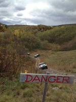
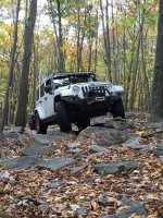
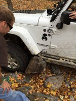
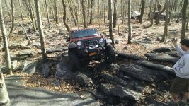
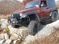
Where did your Jeep take You this Week?

Rausch creek off road park.

Sent from my SAMSUNG-SGH-I337 using WAYALIFE mobile app
 

Attachments

  • 1414076821983.jpg
    1414076821983.jpg
    113.1 KB · Views: 435
  • 1414076836042.jpg
    1414076836042.jpg
    227.9 KB · Views: 442
  • 1414076845467.jpg
    1414076845467.jpg
    153 KB · Views: 439
HB1501,
Looking for somewhere to go this coming weekend. This park isn't far from me. Where does the trail for Jeeps start? Map at the rangers office? Fees?
 
HB1501,
Looking for somewhere to go this coming weekend. This park isn't far from me. Where does the trail for Jeeps start? Map at the rangers office? Fees?

There are no fees, the only place I know to get maps are at the Game check station. It is usually unmanned but they have a box with some in it.
ImageUploadedByWAYALIFE1414496513.867127.jpgImageUploadedByWAYALIFE1414496533.154154.jpg
The check station is on county road 103 about 1/4 mile off of Hwy 35.
103 is about 6-8 miles south of Ft. Payne on the left. When you get to the big bridge on Hwy 35 there is a Little River falls overlook, stop in there they may have some there. Not sure, but worth the stop anyway. 103 is about 2 miles past the bridge, its not marked real well. Let me know if have anymore questions.
When I get home this home this afternoon I'll try to take a picture of the map and post it up.


0lllllll0 Jk
🇺🇸
 
There are no fees, the only place I know to get maps are at the Game check station. It is usually unmanned but they have a box with some in it.
View attachment 107019View attachment 107020
The check station is on county road 103 about 1/4 mile off of Hwy 35.
103 is about 6-8 miles south of Ft. Payne on the left. When you get to the big bridge on Hwy 35 there is a Little River falls overlook, stop in there they may have some there. Not sure, but worth the stop anyway. 103 is about 2 miles past the bridge, its not marked real well. Let me know if have anymore questions.
When I get home this home this afternoon I'll try to take a picture of the map and post it up.


0lllllll0 Jk
🇺🇸

ImageUploadedByWAYALIFE1414530834.998153.jpg
This is a map of the Management area, the area in pink is where the offroad part is. The red numbers in the pink is the road numbers. They are small signs at intersections.
Also on the south side of hwy35 is another part. It is listed as county road 861 and isn't numbered like the north side, it goes out and makes about a 8-10 loop.


OlllllllO Jk
🇺🇸 🇺🇸
 
My jeep (in returned to stockish form) took me to the dealership to get my next jeep...

Out with the old 07 w/ 128k miles
ImageUploadedByWAYALIFE1414547853.809868.jpg

In with the new 2015 w/ 11 miles
ImageUploadedByWAYALIFE1414547869.852360.jpg
 
It took me into the darkness

4c67d571e5eb7a72e283b03086fd9a8e.jpg

68057e9140db4ab51ef3c56792303cd7.jpg


Then to the tire store to buy me some 35s (not these tires but my son likes new tires)
4a1ca6c3981341f19b5e8548ab304648.jpg


Sent from my iPhone using Tapatalk
 
^^ looks awesome! I need to make it up there some time. I act like it's far away or something


Sent from my iPhone using Tapatalk
 
HB1501,

Thanks much for the info and pic. This is exactly the kind of driving I am looking for. Thanks again!
 
It took me to Crescent, NV,
1415610318778.jpg
Rosie's Cabin,
1415610366119.jpg
over Logan Pass (7000+)
1415610644099.jpg
and to see some petroglyphs at the Mount Irish Petroglyph Site.
1415610862252.jpg
1415610942915.jpg

Sent using the WAYALIFE mobile app
 
Is this outside of Vegas?
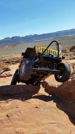
Yes. North of Las Vegas on the east side of the state. If you saw the movie Paul we turned off the pavement near where the world famous "Black Mailbox" was. Also if you didn't see it the Wild West JKX video it really was white. It was permanently removed do to repeated vandalism and mail theft. The last time the rancher went get his mail from it two brilliant souls were trying to take the entire box and post as a souvenir. We met up to start this trip in Alamo, NV.


Sent using the WAYALIFE mobile app
 
Last edited:
Top Bottom