You are using an out of date browser. It may not display this or other websites correctly.
You should upgrade or use an alternative browser.
You should upgrade or use an alternative browser.
Vinton County (Tar Hollow) in Ohio
- Thread starter JKJason
- Start date
wjtstudios
Hooked
JKJason
Caught the Bug
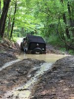
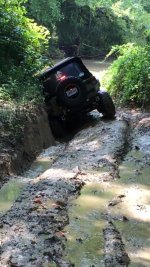
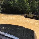
It’s the good ole Midwest. It’s muddy even in a drought out here. I hate mud, but what do you do? :/
nbunga,
These are old unmaintained roads in Vinton County Ohio close to Tar Hollow State Park. There are miles of trails from stock friendly mild to pretty extreme. If you’re interested in more info, I can give you “road” names and tips. I will say that in my opinion, it would be worth the drive for you, but I would recommend having a local run with you the first time because it can be easy to get onto private property if you’re not careful. I use a GPS and it pretty much tells you where the “roads” are.
Sent from my iPhone using WAYALIFE mobile app
Coop
Caught the Bug
It’s the good ole Midwest. It’s muddy even in a drought out here. I hate mud, but what do you do? :/
nbunga,
These are old unmaintained roads in Vinton County Ohio close to Tar Hollow State Park. There are miles of trails from stock friendly mild to pretty extreme. If you’re interested in more info, I can give you “road” names and tips. I will say that in my opinion, it would be worth the drive for you, but I would recommend having a local run with you the first time because it can be easy to get onto private property if you’re not careful. I use a GPS and it pretty much tells you where the “roads” are.
Sent from my iPhone using WAYALIFE mobile app
That looks like fun! Never been there. I’ll have to check that out!
Sent from my iPhone using WAYALIFE mobile app
JKJason
Caught the Bug
Hour and a half from Columbus. How do you stay off private property?
Sent from my iPhone using WAYALIFE mobile app
If you bring a GPS it'll keep you on the road. It's actually really easy. The property owners have their lands clearly marked. There are also road signs hanging up in the trees to show you where the roads are. As long as you don't blaze a new trail, you'll be fine.
eatsleepjeep
New member
Sorry for bringing this thread up from last year but this was the newest and most relevant thread i could find using the search feature. I wanted to see if you could share with me the GPS files for this area? I am in Ohio from time to time and i have looked for the trails (unmaintained public roads) in the Tar hollow area but i didn't have any luck finding them. Any help would be appreciated.If you bring a GPS it'll keep you on the road. It's actually really easy. The property owners have their lands clearly marked. There are also road signs hanging up in the trees to show you where the roads are. As long as you don't blaze a new trail, you'll be fine.
Thanks!
WJCO
Meme King
Sorry for bringing this thread up from last year but this was the newest and most relevant thread i could find using the search feature. I wanted to see if you could share with me the GPS files for this area? I am in Ohio from time to time and i have looked for the trails (unmaintained public roads) in the Tar hollow area but i didn't have any luck finding them. Any help would be appreciated.
Thanks!
Welcome to Wayalife. Probably not going to happen:
https://wayalife.com/showthread.php...S-Coordinates-or-Trail-Directions-on-WAYALIFE


