You are using an out of date browser. It may not display this or other websites correctly.
You should upgrade or use an alternative browser.
You should upgrade or use an alternative browser.
Denver, CO Mile High Meetup Thread
- Thread starter H8ROADS
- Start date
H8ROADS
Caught the Bug
Let's start talking about options for a run soon. I like the option of Chinaman Gulch again. That was a fun trail and there's a lot of easy scenic ones over there we could also do that are likely open this time of year. Timing wise for me would have to be march sometime.
H8ROADS
Caught the Bug
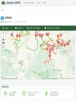
Also, random side note for anyone local who uses GAIA Gps like me - I had an all day dreadfully long remote meeting yesterday and needed something to do while listening for 10 hours. So I downloaded, sorted, color difficulty categorized over 400 GPX files and imported into GAIA so I have basically everything in CO and UT. I had all the trails before but no waypoints. I have it all now, and can export or share if anyone could use it just let me know.
doubletapdaddy
Caught the Bug
Also, random side note for anyone local who uses GAIA Gps like me - I had an all day dreadfully long remote meeting yesterday and needed something to do while listening for 10 hours. So I downloaded, sorted, color difficulty categorized over 400 GPX files and imported into GAIA so I have basically everything in CO and UT. I had all the trails before but no waypoints. I have it all now, and can export or share if anyone could use it just let me know.
That sounds great. I would definitely appreciate it if you could send them my way.

Slimebones
Active Member
Also, random side note for anyone local who uses GAIA Gps like me - I had an all day dreadfully long remote meeting yesterday and needed something to do while listening for 10 hours. So I downloaded, sorted, color difficulty categorized over 400 GPX files and imported into GAIA so I have basically everything in CO and UT. I had all the trails before but no waypoints. I have it all now, and can export or share if anyone could use it just let me know.
400?!?! I would need another lifetime for that!! Working on it.
Also, random side note for anyone local who uses GAIA Gps like me - I had an all day dreadfully long remote meeting yesterday and needed something to do while listening for 10 hours. So I downloaded, sorted, color difficulty categorized over 400 GPX files and imported into GAIA so I have basically everything in CO and UT. I had all the trails before but no waypoints. I have it all now, and can export or share if anyone could use it just let me know.
Everything came up - really excited to start using it. I ended up purchasing the subscription as well.
Thanks again!
Sent from my iPhone using Tapatalk
H8ROADS
Caught the Bug
PM me your email for Gaia and I'll share it to you. Apparently the data set is so large it won't reimport on their website or app, but it does export so if you just want the GPX for another software let me know and I can send you just that.That sounds great. I would definitely appreciate it if you could send them my way.
400?!?! I would need another lifetime for that!! Working on it.
468 to be precise. Admittedly I got a little obsessive but it's neat seeing them all on the screen and now I can look at trails be area on the road much easier, and honestly being able to browse it this way makes trip planning easier, plus now I have waypoint notes which could be helpful.
I also have things in there like HAM repeater locations as well, pop by the house sometime if you want me to show you how to set it up on your phone.
Attachments
Slimebones
Active Member
PM me your email for Gaia and I'll share it to you. Apparently the data set is so large it won't reimport on their website or app, but it does export so if you just want the GPX for another software let me know and I can send you just that.
468 to be precise. Admittedly I got a little obsessive but it's neat seeing them all on the screen and now I can look at trails be area on the road much easier, and honestly being able to browse it this way makes trip planning easier, plus now I have waypoint notes which could be helpful.
I also have things in there like HAM repeater locations as well, pop by the house sometime if you want me to show you how to set it up on your phone.
I will do just that. Of particular interest, the HAM repeater locations. KE0UJQ, 7's
Slimebones
Active Member
Let's start talking about options for a run soon. I like the option of Chinaman Gulch again. That was a fun trail and there's a lot of easy scenic ones over there we could also do that are likely open this time of year. Timing wise for me would have to be march sometime.
Pick a date and we will make it happen.
Bierpower
Hooked
This pretty much sums up my wheeling Outlook for this year. I'll do some easier stuff but it'll be a light year.


Sent from my Pixel 2 XL using WAYALIFE mobile app
Sent from my Pixel 2 XL using WAYALIFE mobile app
H8ROADS
Caught the Bug
Pick a date and we will make it happen.
How does March 14 sit with everyone? Pending weather of course but maybe lets pencil in that date and hope for good weather?
Sent from my iPhone using WAYALIFE
Slimebones
Active Member
How does March 14 sit with everyone? Pending weather of course but maybe lets pencil in that date and hope for good weather?
Sent from my iPhone using WAYALIFE
Is there anything open?
H8ROADS
Caught the Bug
Is there anything open?
Of course, there’s always something open. Unless its super snowy.
Sent from my iPhone using WAYALIFE

boardsurfer
Active Member
Also, say hi to Mae, born 2/11 [emoji1309]
View attachment 342308
Sent from my iPhone using WAYALIFE
Fantastic photo! Congratulations bud.
bigcale
Active Member
How does March 14 sit with everyone? Pending weather of course but maybe lets pencil in that date and hope for good weather?
Sent from my iPhone using WAYALIFE
Going to be in CA that weekend.
Slimebones
Active Member
Also, say hi to Mae, born 2/11 [emoji1309]
View attachment 342308
Sent from my iPhone using WAYALIFE
Welcome Mae. Count me in for the 14th.