You are using an out of date browser. It may not display this or other websites correctly.
You should upgrade or use an alternative browser.
You should upgrade or use an alternative browser.
Trail gps navigation
- Thread starter Gecko13
- Start date
CalSgt
Hooked
Don't waste money on "On-X off road"... Its kinda neat and has a lot of good tools but doesn't seem to show what you need to get to trailheads etc. I bought it for my Moab trip this year & would rather have had the trail guide for the same price.
On a side note the On-X hunt app is worth while if hunting in an area you don't know, especially in CA. it breaks down where private and public lands are, hunt zone borders and a bunch of other helpful tools.
On a side note the On-X hunt app is worth while if hunting in an area you don't know, especially in CA. it breaks down where private and public lands are, hunt zone borders and a bunch of other helpful tools.
wjtstudios
Hooked
I’ve been happy with my Garmin Overland. So far, I’ve been able to download the GPX files for the trails in Moab and Colorado and they were spot on.
MericaMade
Active Member
What's really nice about Gaia is it now integrates into Android auto or Apple carplay.
I use this in the past but didn’t know about this update. Thanks for sharing.What's really nice about Gaia is it now integrates into Android auto or Apple carplay.
CrazyTrainJK
Caught the Bug
Gaia premium is worth it if you do any national forest trails since you can overlay the MVUM and gives you the information on the trails.
wjtstudios
Hooked
True statement, but I guess we’re getting old and that’s not the way anymoreYou know, there was a time when people used to make friends with locals who were knowledgeable about an area and who could take them out on good trails.

LOL - and it hasn't been for quite some time now and to me, it's a shame. The friends I have in the industry today isn't something that I bought on the internet and the places I know, the trails I could take you on, didn't come from tracks on my phone. I should note, what I LOVE about all the old books and paper maps I have, is that they are vague. This allowed me to "explore" and make wonderful mistakes and get lost looking for where I thought I wanted to be and really, I'm eternally grateful for those experiences. To me personally, being handheld everywhere with digital precision... that is really kind of depressing.True statement, but I guess we’re getting old and that’s not the way anymore
WJCO
Meme King
So well said.LOL - and it hasn't been for quite some time now and to me, it's a shame. The friends I have in the industry today isn't something that I bought on the internet and the places I know, the trails I could take you on, didn't come from tracks on my phone. I should note, what I LOVE about all the old books and paper maps I have, is that they are vague. This allowed me to "explore" and make wonderful mistakes and get lost looking for where I thought I wanted to be and really, I'm eternally grateful for those experiences. To me personally, being handheld everywhere with digital precision... that is really kind of depressing.
wjtstudios
Hooked
It does take the essence of the adventure out of it, doesn’t it.LOL - and it hasn't been for quite some time now and to me, it's a shame. The friends I have in the industry today isn't something that I bought on the internet and the places I know, the trails I could take you on, didn't come from tracks on my phone. I should note, what I LOVE about all the old books and paper maps I have, is that they are vague. This allowed me to "explore" and make wonderful mistakes and get lost looking for where I thought I wanted to be and really, I'm eternally grateful for those experiences. To me personally, being handheld everywhere with digital precision... that is really kind of depressing.
AZVAJKU
Hooked
Some of my best trips started with I wonder where that road go’s.
Agreed!! Drive the road and see where it went.
I used to buy the paper USGS maps for $1.50 each, those along with a compass I could figure out where I was at and where I was going. The trails were far less crowded, you had to really put some effort into finding some places. Now thanks to technology there are very few secluded places to go Jeeping.

JT@623
Hooked
That and all the disrespectful assholes that get areas closed. One of the ranchers I know is fixing to lock up some of his gates because people are leaving trash shooting up tanks and windmills cutting fences driving where there are no roads etc.Agreed!! Drive the road and see where it went.
I used to buy the paper USGS maps for $1.50 each, those along with a compass I could figure out where I was at and where I was going. The trails were far less crowded, you had to really put some effort into finding some places. Now thanks to technology there are very few secluded places to go Jeeping.
Colorado4x4
Active Member
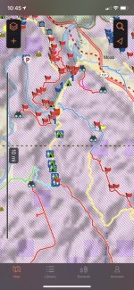
I use the Charles Wells Colorado and Moab guidebook and I have a Delorme inReach satellite messenger that I mostly use for hunting. I use OnX for hunting but haven’t messed with OnX Offroad at all and don’t plan to. The Delorme (Garmin bought them) has an app for the phone. I use google earth and the Delorme website to save tracks and waypoints. When I add a waypoint on the website it shows up on my phone and then is available offline. It works great for me and wouldn’t change anything about it. I do love OnX for hunting because I can save offline satellite images which is awesome while chasing critters. I always get on Google Earth before trips and do a little pre-scouting. I’ve found a ton of unnamed trail offshoots, view points and shit like that which has been awesome. Here’s a screenshot of the app from my phone
Attachments
LOL - I get they're great tools to have but with downloaded tracks and maps that can pinpoint exactly where you're at with GPS precision, are you ever really lost? Being actually lost and having to spend a night or a weekend out on the trail because you really have no idea where you're at or where you're supposed to go... that is a thing of the distant past.Agree on getting lost and making new friends with locals.
Anyway 'gaia' and 'trails offroad' work great for me to search where I want to get lost.
Well, we all have our own idea of what adventure is and I get it. I will say though, I do like the fact that all this new technology keeps most people going to all the same places and that allows lesser known destinations to remain free of crowds.It does take the essence of the adventure out of it, doesn’t it.
")
And to me, that is what made "exploring" so much fun! Cindy and I have literally been lost on top of mountains and in the desert on countless occasions being that we simply couldn't see or find the trail we were on at night or didn't know for sure where we were without visual markers. Those were some of the best times of our life.Agreed!! Drive the road and see where it went.
I used to buy the paper USGS maps for $1.50 each, those along with a compass I could figure out where I was at and where I was going. The trails were far less crowded, you had to really put some effort into finding some places. Now thanks to technology there are very few secluded places to go Jeeping.
There are still secluded places you can go but it takes a lot more effort. My bigger problem is that great destinations are getting destroyed by the masses of people who are now going out to "explore" them.
Last edited:
Colorado4x4
Active Member
Not only that, a lot of these shit asses are going to get trails shut down due to their poor behavior and bad decisions. Not sure if anyone has read any of the news articles over the last couple of years of people rolling off Black Bear Pass, but I predict it will be shut down in the next couple of years if people keep sending their Jeeps and Broncos and 4Runners down the mountain. The town sheriff will figure out a way to close the gates at the bottom somehow. I blame Facebook for a lot of this. Before, someone would either have to go with an experienced wheeler or Jeep group or actually go to a bookstore (which hardly exist anymore) to buy a trail guide book. Now everyone sees off-roading on Facebook and asks “Just got a new Jeep/Bronco. Tell me some good trails to hit!”And to me, that is what made "exploring" so much fun! Cindy and I have literally have literally been lost on top of mountains and in the desert on countless occasions being that we simply couldn't see or find the trail we were on at night or didn't know for sure where we were at with out visual markers. Those were some of the best times of our life.
There are still secluded places you can go but it takes a lot more effort. My bigger problem is that great destinations are getting destroyed by the masses of people who are now going out to "explore" them.